import rastereasy
Stack images
Two options
Return a stacked image (function
stack)Stack directly the original image (function
stackwithinplace=True)
Example by stacking an original image with its clusterised version
1) Return a stacked image (function stack)
1) read an image
names = {"NIR":8,"G":3,"CO" : 1,"SWIR2":11,"B": 2,"R":4,"RE1":5,"RE2":6,"RE3":7,"WA":9,"SWIR1":10,"SWIR3":12}
im1=rastereasy.open('./data/demo/sentinel.tif',names=names,history=True)
help(im1.stack)
Help on method stack in module rastereasy:

stack(
    im_to_stack,
    dtype=None,
    dest_name=None,
    inplace=False,
    reformat_names=False
) method of rastereasy.Geoimage instance
    Stack bands from another image onto this image.

    This method combines the bands from another image with the current image,
    modifying the current image to include all bands from both sources.

    Parameters
    ----------
    im_to_stack : Geoimage
        The image whose bands will be stacked onto this image.
        Should have the same spatial dimensions (rows, cols).

    dtype : str or None, optional
        The data type for the stacked image. If None, an appropriate type is
        determined based on the types of both input images.
        Common values: 'float64', 'float32', 'int32', 'uint16', 'uint8'.
        Default is None.

    dest_name : str, optional
        Path to save the stacked image. If None, the image is not saved.
        Default is None.

    inplace : bool, default False
        If False, return a copy of the stacked image. Otherwise, do stacking in place and return None.

    reformat_names : bool, optional
        If True, band names will be reset to a simple numeric format ("1", "2", "3", ...).
        If False, the function will preserve original band names where possible,
        adding suffixes if needed to resolve conflicts.
        Default is False.

    Returns
    -------
    Geoimage
        The image with additional bands or None if `inplace=True`

    Raises
    ------
    ValueError
        If the spatial dimensions of the images don't match or an unknown dtype is specified.

    Examples
    --------
    >>> # Stack two images with different spectral bands
    >>> optical = Geoimage("optical.tif", names={'R': 1, 'G': 2, 'B': 3})
    >>> thermal = Geoimage("thermal.tif", names={'T': 1})
    >>> combined = optical.stack(thermal)
    >>> print(f"Combined bands: {list(combined.names.keys())}")
    >>>
    >>> # Stack and rename bands sequentially
    >>> combined = optical.stack(thermal, reformat_names=True)
    >>> print(f"After renaming: {list(combined.names.keys())}")
    >>>
    >>> # Stack with explicit data type
    >>> combined = optical.stack(thermal, dtype='float32', dest_name='combined.tif')
    >>>
    >>> # Stack in the image directly
    >>> optical.stack(thermal, reformat_names=True, inplace=True)
    >>> print(f"After renaming: {list(combined.names.keys())}")

    Notes
    -----
    - The bands from both images are combined along the band dimension (axis 0).
    - Band naming conflicts are resolved automatically, adding suffixes if needed.
    - The spatial dimensions (rows, cols) of both images must match.
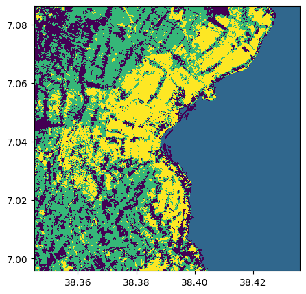
2) computing a clustering (for the example)
im_clust,_ = im1.kmeans(4)
im_clust.visu()
3) Stack the two images with stack
im_stacked=im1.stack(im_clust)
im_stacked.info()
- Size of the image:
   - Rows (height): 1000
   - Cols (width): 1000
   - Bands: 13
- Spatial resolution: 10.0  meters / degree (depending on projection system)
- Central point latitude - longitude coordinates: (7.04099599, 38.39058840)
- Driver: GTiff
- Data type: int32
- Projection system: EPSG:32637
- Nodata: -32768.0

- Given names for spectral bands:
   {'CO': 1, 'B': 2, 'G': 3, 'R': 4, 'RE1': 5, 'RE2': 6, 'RE3': 7, 'NIR': 8, 'WA': 9, 'SWIR1': 10, 'SWIR2': 11, 'SWIR3': 12, '1': 13}
2) Stack directly the original image (function stack with inplace=True)
im1.info()
im1.stack(im_clust, inplace=True)
im1.info()
- Size of the image:
   - Rows (height): 1000
   - Cols (width): 1000
   - Bands: 12
- Spatial resolution: 10.0  meters / degree (depending on projection system)
- Central point latitude - longitude coordinates: (7.04099599, 38.39058840)
- Driver: GTiff
- Data type: int16
- Projection system: EPSG:32637
- Nodata: -32768.0

- Given names for spectral bands:
   {'CO': 1, 'B': 2, 'G': 3, 'R': 4, 'RE1': 5, 'RE2': 6, 'RE3': 7, 'NIR': 8, 'WA': 9, 'SWIR1': 10, 'SWIR2': 11, 'SWIR3': 12}

--- History of modifications---
[2025-12-06 09:21:53] - Read image ./data/demo/sentinel.tif


- Size of the image:
   - Rows (height): 1000
   - Cols (width): 1000
   - Bands: 13
- Spatial resolution: 10.0  meters / degree (depending on projection system)
- Central point latitude - longitude coordinates: (7.04099599, 38.39058840)
- Driver: GTiff
- Data type: int32
- Projection system: EPSG:32637
- Nodata: -32768.0

- Given names for spectral bands:
   {'CO': 1, 'B': 2, 'G': 3, 'R': 4, 'RE1': 5, 'RE2': 6, 'RE3': 7, 'NIR': 8, 'WA': 9, 'SWIR1': 10, 'SWIR2': 11, 'SWIR3': 12, '1': 13}

--- History of modifications---
[2025-12-06 09:21:53] - Read image ./data/demo/sentinel.tif
[2025-12-06 09:21:53] - Stacked 1 bands (1) onto existing 12 bands. Output type: int32. Band names were combined without modification (no conflicts).
Create Stack from files
You can use the rastereasy.files2stack function to stack different files
help(rastereasy.files2stack)
Help on function files2stack in module rastereasy:

files2stack(
    imagefile_path,
    resolution=None,
    names='origin',
    dest_name=None,
    ext='jp2',
    history=False
)
    Create a stacked Geoimage from multiple single-band images.

    This function creates a multi-band Geoimage by stacking individual images,
    either from a list of image paths or from all images in a directory.
    All input images should have 1 band each.

    Parameters
    ----------
    imagefile_path : str or list of str
        - If a list of strings: paths to image files to stack (e.g., ['image1.jp2', 'image2.jp2', ...])
        - If a string: path to a directory containing images with the specified extension
    resolution : float, optional
        Resolution to which all images will be resampled. If None, all images must
        have the same resolution already.
        Default is None.
    names : dict or str, optional
        How to name the spectral bands in the stack:
        - If a dict: Maps band names to indices (e.g., {'B': 1, 'G': 2, 'R': 3, ...})
        - If "origin" (default): Uses the original filenames as band names
        - If None: Assigns numeric names ('1', '2', '3', ...)
        Default is "origin".
    dest_name : str, optional
        Path to save the stacked image as a TIFF file.
        Default is None (no file saved).
    ext : str, optional
        File extension of images to load if imagefile_path is a directory.
        Default is 'jp2'.
    history : bool, optional
        Whether to enable history tracking for the output Geoimage.
        Default is False.

    Returns
    -------
    Geoimage
        A stacked Geoimage containing all the input images as bands.

    Examples
    --------
    >>> # Stack from a list of image files
    >>> list_images = ['band1.jp2', 'band2.jp2', 'band3.jp2']
    >>> stacked_image = files2stack(list_images)
    >>> stacked_image.save('stacked.tif')
    >>>
    >>> # Stack all jp2 files from a directory with resolution resampling
    >>> folder_path = './my_bands_folder'
    >>> stacked_image = files2stack(folder_path, resolution=10)
    >>> stacked_image.info()

    Notes
    -----
    This function is particularly useful for combining separate band files (common in
    satellite imagery) into a single multi-band image for analysis.
1) By specifying the list of files
list_tif=['./data/demo/tostack/G5_B2.tif','./data/demo/tostack/G5_B3.tif','./data/demo/tostack/G5_B4.tif','./data/demo/tostack/G5_B8.tif']
resolution=10

stack1=rastereasy.files2stack(list_tif,resolution=resolution)
stack1.info()
- Size of the image:
   - Rows (height): 2370
   - Cols (width): 3144
   - Bands: 4
- Spatial resolution: 10.0  meters / degree (depending on projection system)
- Central point latitude - longitude coordinates: (47.60615500, -2.57780166)
- Driver: GTiff
- Data type: uint16
- Projection system: EPSG:32630

- Given names for spectral bands:
   {'G5_B2': 1, 'G5_B3': 2, 'G5_B4': 3, 'G5_B8': 4}
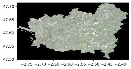
2) By giving the folder and extension of contained files
rep='./data/demo/tostack/'
ext='tif'
stack2=rastereasy.files2stack(rep,ext=ext,dest_name='./data/results/stack/stack.tif',resolution=resolution)
stack2.info()
# Check the identify between stacked images
print('Differences between images : ', (stack2-stack1).abs().sum())
- Size of the image:
   - Rows (height): 2370
   - Cols (width): 3144
   - Bands: 4
- Spatial resolution: 10.0  meters / degree (depending on projection system)
- Central point latitude - longitude coordinates: (47.60615500, -2.57780166)
- Driver: GTiff
- Data type: uint16
- Projection system: EPSG:32630

- Given names for spectral bands:
   {'G5_B2': 1, 'G5_B3': 2, 'G5_B4': 3, 'G5_B8': 4}


Differences between images :  0
stack2.colorcomp()