import rastereasy
Resampling
name_im='./data/demo/sentinel.tif'
image=rastereasy.open(name_im)
image.info()
- Size of the image:
   - Rows (height): 1000
   - Cols (width): 1000
   - Bands: 12
- Spatial resolution: 10.0  meters / degree (depending on projection system)
- Central point latitude - longitude coordinates: (7.04099599, 38.39058840)
- Driver: GTiff
- Data type: int16
- Projection system: EPSG:32637
- Nodata: -32768.0

- Given names for spectral bands:
   {'1': 1, '2': 2, '3': 3, '4': 4, '5': 5, '6': 6, '7': 7, '8': 8, '9': 9, '10': 10, '11': 11, '12': 12}
help(image.resample)
Help on method resample in module rastereasy:

resample(
    final_resolution,
    dest_name=None,
    inplace=False,
    method='cubic_spline',
    update_history=True
) method of rastereasy.Geoimage instance
    Resample the image to a different resolution.

    This method changes the spatial resolution of the image by resampling the pixel values.
    The resampling process creates a new grid of pixels at the target resolution and
    interpolates values from the original grid.

    Parameters
    ----------
    final_resolution : float
        The target resolution in the image's coordinate system units (typically meters or degrees).
        A smaller value results in a higher-resolution (larger) image.

    dest_name : str, optional
        Path to save the resampled image. If None, the image is not saved.
        Default is None.

    inplace : bool, default False
        If False, return a copy. Otherwise, do the resampling in place and return None.


    method : str, optional
        Resampling algorithm to use. Options include:

        - 'cubic_spline' (default): High-quality interpolation, good for continuous data

        - 'nearest': Nearest neighbor interpolation, preserves original values, best for categorical data

        - 'bilinear': Linear interpolation between points, faster than cubic

        - 'cubic': Standard cubic interpolation

        - 'lanczos': High-quality downsampling

        - 'average': Takes the average of all contributing pixels, useful for downsampling

    update_history : bool, optional
        Whether to update the image processing history. Default is True.

    Returns
    -------
    Geoimage
        A copy of the resampled image or None if `inplace=True`

    Examples
    --------
    >>> # Resample to 30 meter resolution
    >>> image_resampled = image.resample(30)
    >>> print(f"New resolution: {image.resolution}")
    >>>
    >>> # Resample using nearest neighbor (best for categorical data)
    >>> classified_image_resampled = classified_image.resample(10, method='nearest')
    >>>
    >>> # Resample and save the result
    >>> image_resampled = image.resample(20, dest_name='resampled_20m.tif')
    >>>
    >>>
    >>> # Resample directly the image to 30 meter resolution
    >>> image.resample(30, inplace=True)
    >>> print(f"New resolution: {image.resolution}")
    >>>
    >>> # Resample directly the image using nearest neighbor (best for categorical data)
    >>> classified_image.resample(10, method='nearest', inplace=True)
    >>>
    >>> # Resample and save the result
    >>> image.resample(20, dest_name='resampled_20m.tif', inplace=True)

    Notes
    -----
    - Same function as `resampling` but rather prefer this one
    - When upsampling (to higher resolution), no new information is created;
    the function only interpolates between existing pixels
    - When downsampling (to lower resolution), information is lost
    - The choice of resampling method is important:
    - For continuous data (e.g., elevation, reflectance): 'cubic_spline', 'bilinear', or 'cubic'
    - For categorical data (e.g., land classifications): 'nearest' or 'mode'
    - This method changes the dimensions (shape) of the image
Two options
Return a resampled image (function
resample)Resample the image (function
resamplewith optioninplace=True)
1) Return a resampled image
final_resolution=150
print('Before resampling')
image.info()
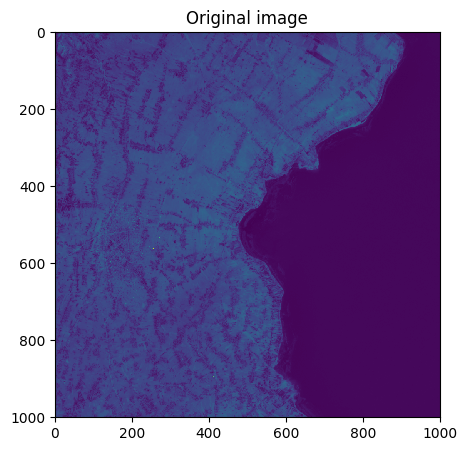
image.visu("4",title='Original image',extent='pixel')
resampled_image=image.resample(final_resolution=final_resolution,dest_name='./data/results/resampling/resampled.tif')
print('After resampling')
resampled_image.info()
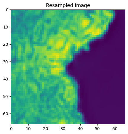
resampled_image.visu("4",title='Resampled image',extent='pixel')
Before resampling
- Size of the image:
   - Rows (height): 1000
   - Cols (width): 1000
   - Bands: 12
- Spatial resolution: 10.0  meters / degree (depending on projection system)
- Central point latitude - longitude coordinates: (7.04099599, 38.39058840)
- Driver: GTiff
- Data type: int16
- Projection system: EPSG:32637
- Nodata: -32768.0

- Given names for spectral bands:
   {'1': 1, '2': 2, '3': 3, '4': 4, '5': 5, '6': 6, '7': 7, '8': 8, '9': 9, '10': 10, '11': 11, '12': 12}
After resampling
- Size of the image:
   - Rows (height): 66
   - Cols (width): 66
   - Bands: 12
- Spatial resolution: 151.51515151515153  meters / degree (depending on projection system)
- Central point latitude - longitude coordinates: (7.04035679, 38.39122988)
- Driver: GTiff
- Data type: int16
- Projection system: EPSG:32637
- Nodata: -32768.0

- Given names for spectral bands:
   {'1': 1, '2': 2, '3': 3, '4': 4, '5': 5, '6': 6, '7': 7, '8': 8, '9': 9, '10': 10, '11': 11, '12': 12}
2) Resampled the image directly
final_resolution=15
print('Before resampling')
image.info()
image.resample(final_resolution=final_resolution, inplace=True)
print('Before resampling')
image.info()
Before resampling
- Size of the image:
   - Rows (height): 1000
   - Cols (width): 1000
   - Bands: 12
- Spatial resolution: 10.0  meters / degree (depending on projection system)
- Central point latitude - longitude coordinates: (7.04099599, 38.39058840)
- Driver: GTiff
- Data type: int16
- Projection system: EPSG:32637
- Nodata: -32768.0

- Given names for spectral bands:
   {'1': 1, '2': 2, '3': 3, '4': 4, '5': 5, '6': 6, '7': 7, '8': 8, '9': 9, '10': 10, '11': 11, '12': 12}


Before resampling
- Size of the image:
   - Rows (height): 666
   - Cols (width): 666
   - Bands: 12
- Spatial resolution: 15.015015015015013  meters / degree (depending on projection system)
- Central point latitude - longitude coordinates: (7.04097334, 38.39061114)
- Driver: GTiff
- Data type: int16
- Projection system: EPSG:32637
- Nodata: -32768.0

- Given names for spectral bands:
   {'1': 1, '2': 2, '3': 3, '4': 4, '5': 5, '6': 6, '7': 7, '8': 8, '9': 9, '10': 10, '11': 11, '12': 12}